 Магазин
GPS vs LBS vs Wi-Fi vs iBeacon Positioning
GPS, LBS, Wi-Fi, и iBeacon positioning answer the same question — where is this device — at very different scales. GPS uses satellites and works in the open. LBS uses cell towers and stays coarse. Wi-Fi positioning uses access points inside a building. iBeacon positioning uses a Bluetooth Low Energy broadcast to say “you are near this spot,” not “you are at this latitude.”
The difference between GPS, LBS, Wi-Fi, и iBeacon positioning is the signal each one measures, and the kind of result you can honestly expect. Mixing them up leads to a system that looks precise on a slide and fails in the building.
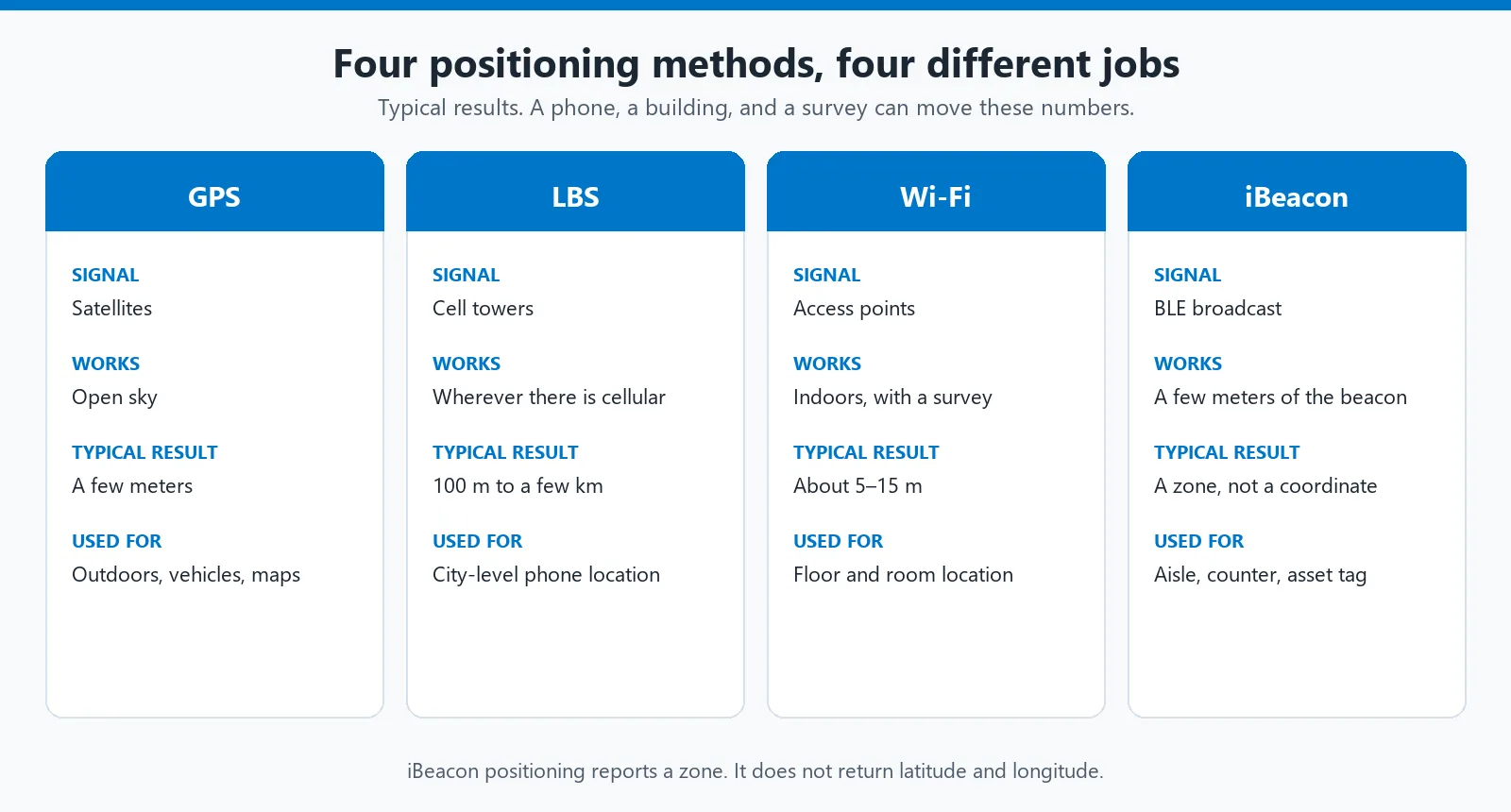
Each method reports a different kind of location. The numbers are typical, not a guarantee for every phone or building.
GPS, LBS, Wi-Fi, and iBeacon positioning compared
| Method | What it measures | Where it works | Typical result |
|---|---|---|---|
| GPS positioning | Travel time of signals from satellites | Outdoors, with a view of the sky | A few meters in open sky. Poor or unavailable indoors. |
| LBS positioning | Which cell towers the phone can hear | Anywhere with cellular coverage | О 100 meters in a dense city, up to a few kilometers in the countryside. |
| Wi-Fi positioning | Nearby access-point identities and signal strength | Indoors, where access points are mapped | Often 5–15 meters after a site survey. A public router database is usually coarser. |
| iBeacon positioning | А БЛЕ advertising packet and its RSSI | Within a few meters of a маяк | A zone: immediate, near, or far. Not a map coordinate. |
None of these replaces the others. A delivery van needs GPS. A phone that has lost the sky can fall back to LBS. A hospital floor needs Wi-Fi or beacons, because satellites do not reach the corridor.
GPS positioning
GPS positioning is satellite navigation. The receiver measures how long a signal took to arrive from several satellites whose orbits are known, then computes its own position. A phone usually blends GPS with other constellations (GLONASS, Galileo, BeiDou). People still call the result GPS.
Under an open sky, a phone is often within a few meters of the true point. Tall buildings, a deep street, or a roof will stretch that error or remove the fix entirely. GPS does not provide a reliable indoor position. Repeating “high precision” without saying “outdoors” is how indoor projects get scoped around the wrong radio.
GPS also supplies speed and time. Those matter for vehicles and for synchronizing logs. They do not help a retailer know which shelf a shopper is standing at.
LBS positioning
LBS means location-based services. In mobile networks it usually means cellular positioning: the phone reports the cell it is camped on, and sometimes the signal levels of neighboring cells. The network, or a location server, turns that into a coordinate because each tower already has a known position.
This is not Bluetooth, and it is not a measurement between a Bluetooth-модуль and a base station. A cell can cover a few hundred meters in a city or several kilometers in the countryside, so LBS positioning is a district or a neighborhood, not a room. Assisted GPS uses the cellular network only to help the phone find satellites faster. The accurate fix, when it arrives, is still GPS.
LBS is useful when an app needs a rough location and GPS is off, slow, or blocked. It is the wrong tool for indoor navigation.
Wi-Fi positioning
Wi-Fi positioning treats access points as landmarks. Every access point broadcasts a MAC address. A phone or tag can read that address and the signal strength without joining the network, including when the network is hidden from the user’s Wi-Fi list.
Two different systems share this name.
Router-database lookup. The device sends the MAC addresses it can hear to a server that already knows roughly where those routers are. The result is good enough to place a phone on the right block. It is often tens of meters off, and it gets worse if the access point has moved since the database was built.
Indoor survey. You walk the building, record signal patterns, and later match a live scan to that map. With enough access points this can land in the right room, commonly on the order of 5–15 meters. The survey goes stale when furniture, walls, or access points change.
Wi-Fi positioning needs infrastructure that is already powered all day. It is a poor fit for a battery tag that must last for years, and it still will not tell you which side of a counter someone is on.
iBeacon positioning
iBeacon is a Bluetooth Low Energy packet format Apple published in 2013. The packet carries a UUID, a Major number, and a Minor number, plus a calibrated power value. A nearby phone or gateway reads that identifier and the received signal strength. It does not pair, and it does not join a network.
iBeacon positioning is proximity. A stronger signal usually means the listener is closer, but walls, bodies, and the way a phone is held move the reading around. Treat the result as a zone — immediate, near, or far — or as “this маяк was heard by that gateway.” One маяк does not calculate latitude and longitude. You assign the meaning of its ID in your own software: this ID is the entrance, this ID is bed 12.
That is also why the old store example still holds, without the 2013 phone attached to it. A retail app that is allowed to scan can notice the store’s beacon and open a page, a coupon, or a wayfinding step. The beacon only broadcasts. The app decides what to show. The same pattern works for an asset tag: gateways in the building report which beacon they can hear.
iOS can monitor iBeacon regions in the background when the user has granted location permission. Android needs an app that scans. A deeper look at the packet, the RSSI limits, and battery life is in how a Bluetooth beacon works.
iBeacon is the 2013 proximity format. It is not the newest indoor method. Bluetooth 5.1 added Angle of Arrival (АОА) and Angle of Departure (AoD): several antennas measure the direction of the same БЛЕ packet, and a set of anchors can turn that into a coordinate. Физикомх beacon and gateway line uses both layers. An iBeacon such as the FSC-BP103C is the zone marker. The АОА kit uses FSC-BP10x tags and the FSC-BP203 anchor, и Физиком states sub-meter results for that anchor network, including when it is connected to FeasyCloud. A single iBeacon still does not produce that coordinate.

GPS and LBS cover the outside. Wi-Fi and iBeacon cover the inside, and only where you have installed the hardware.
Where Feasycom modules fit
Физиком does not make the GPS receiver or the cellular location service. GPS positioning and LBS positioning stay outside the module catalog. The hardware Feasycom ships is the indoor radio, and the current parts are Bluetooth 6.0 и Wi-Fi 7, not the 2013 beacon by itself.
Beacons for iBeacon positioning. Beacons, tags, and gateways advertise iBeacon, Эддистоун (UID, URL-адрес, and TLM), and custom БЛЕ frames. The phone or a gateway reads the ID and the RSSI. That is the zone result described above. Parameters such as interval, передавать мощность, UUID, Major, and Minor are set in the FeasyBeacon app.
АОА when a zone is not enough. Direction finding needs an anchor, not a louder beacon. The FSC-BP203 is the AoA location anchor. FSC-BP10x tags are the devices being located. FSC-BT2024NI is the module for a design that has to do this itself: Nordic nRF54L15, Bluetooth 6.0, Нить, и Зигби, with AoA and AoD on the chip. Published radio figures for that module are transmit power from −8 dBm to +8 dBm and −96 dBm receive sensitivity at 1 Мбит/с. It is controlled with ASCII commands over UART. The module supplies the direction-finding radio. The coordinate still comes from the anchor layout and the location software.
Wi-Fi модули are not a Wi-Fi positioning system. Feasycom Wi-Fi modules are connectivity parts: Wi-Fi 4, 5, 6, и 7, usually combined with Bluetooth, some of them dual-band and some automotive. The FSC-BW5028MV, for example, is a Wi-Fi 7, Bluetooth 5.4, and 4G module for a vehicle. It gets a device onto a network. It does not survey a building or compute a Wi-Fi position. If a product needs Wi-Fi positioning, the access-point map and the location server are still a separate system. A newer Wi-Fi generation does not tighten that position by itself.
Which positioning method should you use?
Pick the method from the decision you need, not from the smallest number on a datasheet.
Use GPS positioning when the asset is outdoors and a few meters is enough: vehicles, yards, and any map that already assumes a satellite fix.
Use LBS positioning when you only need a city or a district, or as a fallback while GPS has no fix. Do not promise a room.
Use Wi-Fi positioning when the building already has access points and you can survey it. Plan to repeat the survey after the layout changes.
Use iBeacon positioning when the question is “which zone?” rather than “which coordinate?”. A counter, a dock door, a bed, or a tool crib is a beacon job. Sub-meter tracking is AoA: anchors such as the FSC-BP203 and tags such as the FSC-BP10x series, not a single iBeacon turned up louder.
Most sites use more than one. GPS or LBS while the person or vehicle is outside, then Wi-Fi or iBeacon after they come through the door. The handoff only works if your software treats them as different kinds of evidence, instead of forcing a beacon zone onto a latitude.
Часто задаваемые вопросы
What is the difference between GPS and iBeacon positioning?
GPS positioning computes a coordinate from satellites and needs a view of the sky. iBeacon positioning only reports that a phone or gateway is near a Bluetooth-маяк. GPS is for outdoors. iBeacon is for a zone indoors.
Is LBS the same as GPS?
Нет. LBS positioning on a phone usually means the cellular network, using cell towers. GPS is satellite positioning. Assisted GPS may use the cellular network to speed up the first satellite fix, but the accurate point still comes from the satellites.
Can Wi-Fi positioning work without joining the network?
Да. The device only needs the access point’s MAC address and signal strength. Those are broadcast. Connecting to the Wi-Fi is a separate step and is not required for the position calculation.
Does an iBeacon return latitude and longitude?
Нет. The packet contains an identifier, not a coordinate. Your platform attaches a place to that identifier. Signal strength suggests a zone. It does not produce a GPS-style point.
Which method works indoors?
Wi-Fi positioning and iBeacon positioning. GPS positioning usually fails indoors. LBS positioning still returns a result indoors, but that result is the cell area, which can be hundreds of meters wide. For a coordinate inside the building, RSSI from one iBeacon is not enough. That result needs an AoA anchor network.